Enjoy My Video OF My Last Post!
Thursday, June 11, 2009
Wednesday, May 20, 2009
Seventh and Final Stop
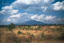
Our last location is the Central Lowlands. It is in Australia, which the capital is Sydney. It is surrounded by the Indian Ocean. Papa New Ginuea is the only only country that borders this country. The GPS coordinates are 25°16'27.64"S, 133°46'24.83"E. This is the hottest and driest location that I have been in. It is very dry and grassy, so dry the grass is very brittle. There is a great history of wildfires in this place. It is important because it is home to several species of animals. It is 4,147 miles from the last place I was. We flew to our last place by an enormus jet plane. It cost over $30,000 dollars to complete our trip. I learned that there are several different animals then there are in the U.S.A, and my family is extremely excited that I am home. Well now my blog is done! BYE!
Tuesday, May 19, 2009
Fifth Stop
Hi again! We are now in the North China Plains, of course it's in China, the capital is Beijing. It is surrounded by Mongolia, Nepal, and several smaller countries. The GPS coordinates are 34°10'56.15"N, 100°59'58.87"E. The climate of these plains is very nice, not to hot or cold, and is super green. There is a great history in these plains, the Great Wall of China borders these plains! Thats awesome! This is a very important part of their history, that causes most of the tourists, other than the Olympics, which is not very often. It is 4623.33 miles from the North European Plains. We flew by plain, which cost us nearly $5,000, we had no problems with our flight, which is great! The biggest difference in the locations is that this one has way more rocks and grass.
Monday, May 18, 2009
Fourth Stop
This week my family and I are visiting the North European Plain. It is in the country of Russia, the capitol is Moscow. There are several countries that border Russia, such as Finland. The pacific ocean is the only body of water that borders this country. The GPS coordinates are 49°33'15.38"N, 7° 9'59.98"E, and the climate is fairly cool. The reason for that is because this location is farther from the equator than the other locations. This location is same old grass as the other ones, except maybe a little greener. The cool thing about this location is that the North European Plains extend into Asia. We flew in to our this location again, only because my parents and I want to be back home in 7 weeks. We didn't have any layovers. Due to all the fun scenes that I have seen, I think that this trip has been exciting. Our trip cost us over $4,000. It is 3613.42 miles from the last location.
Friday, May 15, 2009
Third Stop
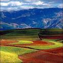
Now we are in the Masai Mara, which is in Tanzania. The capital of Tanzania is Dar es Salaam. Kenya, Somalia, DR Congo, Mozambique, Zambia, and the Indian Ocean border Tanzania. The GPS coordinates are 37°49'8.68"E, 0° 0'24.84"N The climate of this area is warm and sunny, mostly because it is by the equator. HOT!!! This is where the Masai Natives have lived for several years, and now they are getting kicked out due to the protection of the African Lions. It is about 3,870. We had to fly across the Atlantic Ocean, and most of Africa. We flew by jet plane to Tanzania and it cost $5,468, also our luggage got lost, but we found it.
Monday, May 11, 2009
Second Stop
Hi Again! I am now in the Pampas, by the way, Its in Argentina!!! The capital of Argentina is
Buenos Airies, and is surrounded by Chile, Uruaguay, and Paraguay, the Atlantic, and Pacific Oceans. The GPS coordinates are 58°25'2.31"W, 34°36'42.42"S The climate of the location is pretty warm, and very very grassy. We flew to the Pampas, which is 3,200 miles from the Interior Plains. The trip from the Interior Plains to the Pampas was $2,638.
Buenos Airies, and is surrounded by Chile, Uruaguay, and Paraguay, the Atlantic, and Pacific Oceans. The GPS coordinates are 58°25'2.31"W, 34°36'42.42"S The climate of the location is pretty warm, and very very grassy. We flew to the Pampas, which is 3,200 miles from the Interior Plains. The trip from the Interior Plains to the Pampas was $2,638.
Friday, April 10, 2009
First Stop
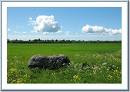
The first place we stopped in was The Interior Plains. It is in the U.S.A and its capitol is Washington D.C., and the U.S.A. is bordered by Mexico and Canada, and is surrounded by the Atlantic, and Pacific Oceans, and the Gulf Of Mexico. I am not sure what the GPS Coordinates are at the moment, but I will find out soon. The climate is pretty warm here but there are are some cold spots, because they extent up into Canada. There is a bunch of grass and this was once the home of the Sioux Indians, so this was a very important place because it was a home to Indians.
Well I gotta go to our next place. Bye!!!
Well I gotta go to our next place. Bye!!!
Subscribe to:
Comments (Atom)